19th Century ‘Chick-Chock’ boundary stones located
CONTRIBUTED BY KC Cole, Public Affairs., Media Relations.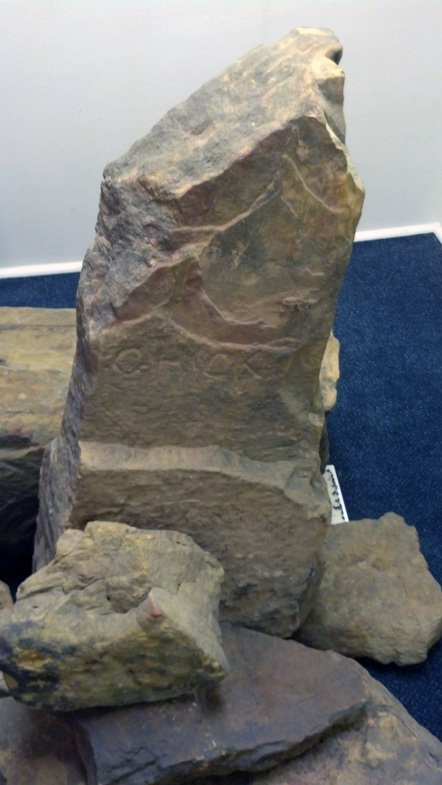
This article appeared in the September 2014 edition of the Chickasaw Times
Anthony Prince made an amazing discovery while exploring property recently purchased near Allen, Okla. Roaming aimlessly to get the feel of his land, he found himself deep inside a rough creek bed within a large stand of overgrown trees. Looking up from the creek, an unnatural rock protruding from the steep bank caught his eye.
With a uniform shape eight inches square by one and one-half foot tall, Mr. Prince knew this man-made rock must have been placed in the inhospitable location for a reason. Climbing up the overgrown bank, he ran his hand over the inscriptions chiseled on its surface and read the weathered words, “Chick” on one side and “Chock” on the other.
Little did he know he was touching a rare historical artifact. This stone had been placed by the Chickasaw Nation representing the reestablishment of tribal lands and separation from the Choctaw Nation more than 150 years ago.
“What he had found was an original stone boundary marker placed between the Choctaw and Chickasaw Nations,” Chickasaw Nation GeoSpatial Information Specialist Brian McCurdy said. “It is something special. The land to the west of this marker belongs to the Chickasaws and the land to the east the Choctaws. We only know the exact locations of 10 of these original survey markers. Most have been destroyed by the elements or cleared by farmers.”
A total of 65 markers were positioned - one per mile - to identify the boundaries between the two nations. They were placed by surveyors hired by the Chickasaw Nation after the tribe purchased the western portion of the Choctaw Nation in the mid-19th century. Most survey markers have not survived because they were not stone but were symbols carved into live trees and timber in the area.
“The surveyors of the time used existing trees to carve surveying symbols known as hack and blaze markings into their trunk,” Mr. McCurdy said. “Markers from this time period are rare. The trees have been cleared for farmland or the marks (in trees) have naturally grown over. All the survey markers we have identified are made of stone survey monuments.”
To date, 10 stone monuments have been rediscovered by the Chickasaw Nation. Records of their locations have been updated to include state-of-the-art global positioning coordinates and detailed photographs. This includes one found near Kullihoma currently on display at the Council House Museum in Tishomingo, Okla.
The Chickasaw Nation began searching in earnest for survey monuments more than a year ago. Like crime scene investigators, staff members of the GeoSpatial Informational Department (GIS) use a combination of common sense, 21st century technology and old-fashioned leg work to find the stone monuments.
Using advanced software called ArcMap, original 1871 maps provided by the federal Bureau of Land Management are superimposed onto current topographic and survey maps. This allows Mr. McCurdy to approximate where the markers are located and who currently owns the land.
“The original maps and surveys are great,” he said. “Considering the technology surveyors used in the 1870s, the markers locations are almost spot-on where they should be. Stone monuments are typically within 100 feet of where I thought.”
Accuracy is important when in the field. A few of the stone monuments are located deep in Oklahoma’s overgrown wilderness. It can take up to half a day to hike to and scout a single location, with the seasons playing havoc on the process.
“We began field work last summer,” Mr. McCurdy said. “It took me most of the morning to walk through the overgrown meadows and tree stands to even begin searching for the first monument. It was late afternoon before I found it. The temperature was well into the 90s and I left my water in the truck. I was worn out.”
Field searches were suspended until the winter months when heat exhaustion and dense vegetation wouldn’t be a concern.
Before field work begins, GIS identifies current owners of the property where stone monument markers are suspected to be located. As the border between the Chickasaw and Choctaw Nations, permission from two separate owners is often needed before employees enter the properties.
“Many markers are near or on the property lines of two separate owners,” Mr. McCurdy said. “We contact both to get permission to look for the markers. Most are excited to learn about their property and are happy to let us have a look around. They get really excited if we find a marker.”
Of the 65 locations where markers are located, only two have not been searched.